I may be feeling discouraged about certain parts of my creative and professional life, but in addition to the France trip one thing I'm undeniably psyched about is the beginning of hiking season. David and I got out a few times for preliminary hikes in February and March, but this Friday we picked up our Northwest Forest Pass (an annual pass that allows you to park at any of the trailheads in Oregon and Washington), which officially signals the opening of our personal Hiking Season 2011. When I'm feeling down I tend to get (metaphorically) itchy feet, and do battle with the urge to go adventuring. I'm so lucky to live in a region with hundreds of possibilities for beautiful outdoor exploring within a few hours' drive of my home. Even if those "few hours" turn out, like yesterday, to be a few MORE than anticipated.
We were headed to Siouxon Creek (pronounced "Susan"), in Gifford Pinchot National Forest. Here is how our formerly-trusty guide book directs you to get there:
From Vancouver, drive north on I-5 to Highway 503 (Woodland, exit 21). Drive east 45 miles to Pine Creek Information Center. Turn right and continue on Forest Service Road 90 to Northeast Healy Road in the town of Clehatchie. Turn right and drive 10 miles to Forest Service Road 57. Turn left and drive 1.5 miles to Forest Service Road 5701. Turn left and drive 4 miles to the trailhead at road's end.
My first clue as to what a completely nonsensical pile of rubbish this is, should have been when I tried to Google-map Portland to Clehatchie, and Google told me that they "could not understand this location." Let me explain.
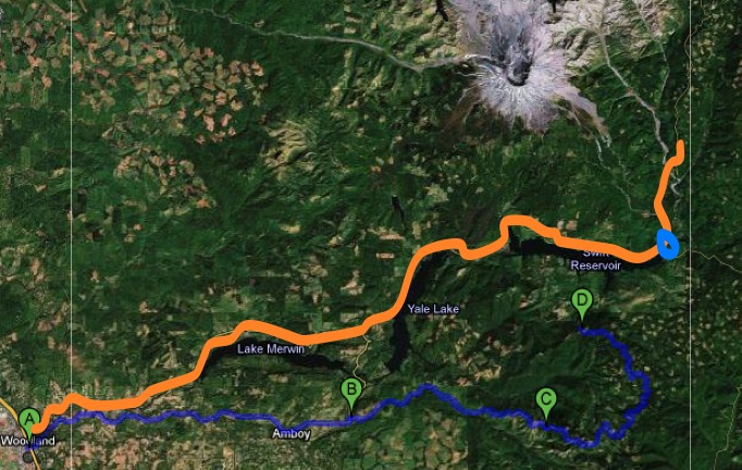
Very approximately, we were trying to get to Point D. If you attempt to follow the instructions, though, they will take you along the orange route instead. That's what happens if you "drive 45 miles to Pine Creek Information Center," represented by the blue circle. It's confusing because you actually CAN drive 45 miles and you actually WILL arrive at Pine Creek Information Center, at which point you actually can turn right and continue on 90. The only problem is, you will be NOWHERE NEAR the trailhead you are looking for, and you will be driving farther away all the time. You can drive as long as you want on 90 and you will never be able to turn right on "Northeast Healy Road in the town of Clehatchie," for three reasons:
1. The turnoff to Northeast Healy Road is all the way back at Point B, and
2. The town in which it's located is called CHELATCHIE, and finally
3. The turn you need to make when you get there is actually a T-bone left.
What's more, because everything to the east of Pine Creek is tiny dead-ending Forest Service Roads, you really can't get from there to Siouxon Creek without back-tracking almost the entire way back to Point A. Which we did. And, in a perfect storm of hilarity, the area around Chelatchie is covered on our map by handy informational boxes about mountain safety, so we pretty much had to figure it out on our own. It took about five hours of driving in total, which, to put it in perspective, would have taken us almost to the Canadian border if we had just stayed on I-5.
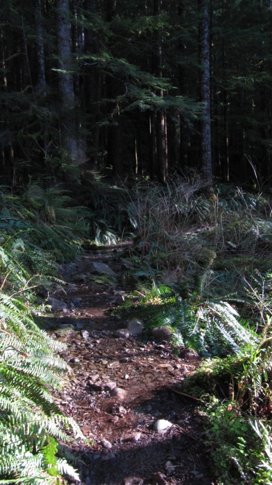
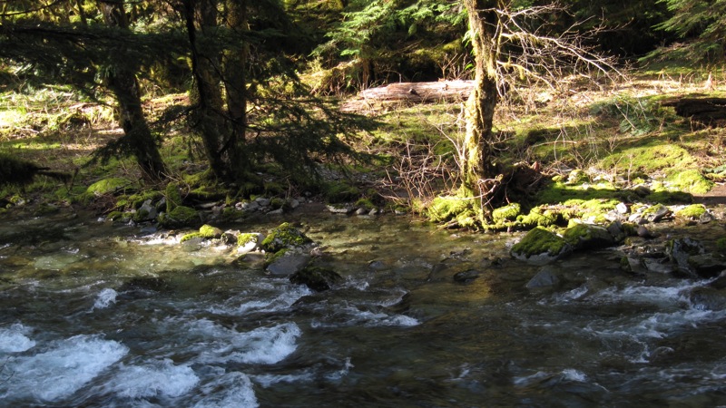
It was actually fun. We were laughing the whole time. I kind of enjoy getting lost and figuring out where I am again; it's that sense of hysterical adventure. Luckily, also, we got going quite early in the day, so after we finally got to Siouxon Creek, flushed and exultant with our navigational ingenuity, we still had time to do it justice. And what a gorgeous hike it was! Meandering along by the side of the river as the clear, blue-green water rippled along pebble beds...
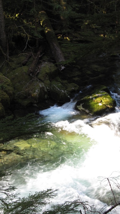
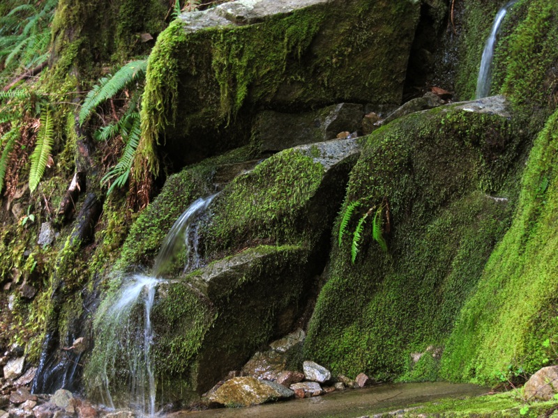
...dripped off moss- and fern-covered rock walls...
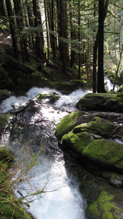
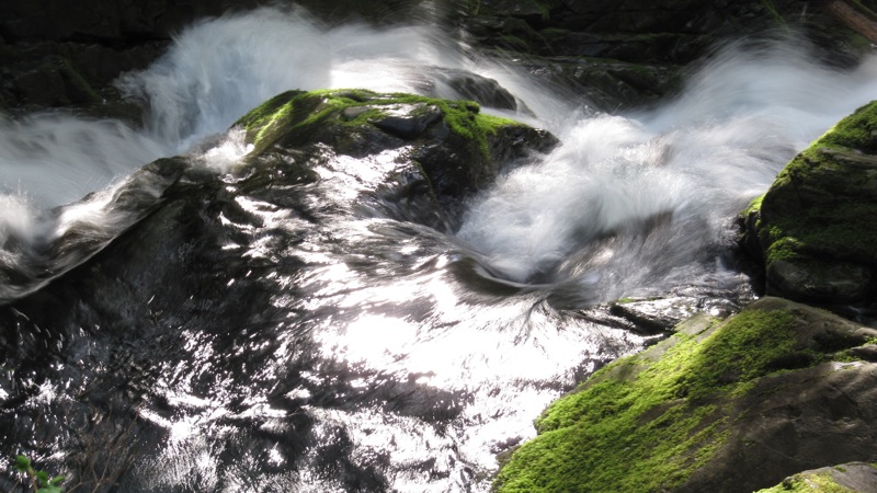
...and thundered down waterfall, after waterfall...
...after waterfall.
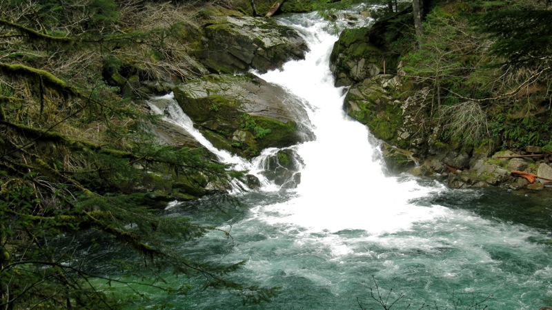
Seriously, I lost count of the waterfalls. I didn't even get photos of the flashiest ones, because they were too big. This trail is quite a study in the different characters of waterfalls: you see falls that are tall trickles, misting down the mossy sides of rocks, and falls that crash down two hundred feet into deep blue roiling cauldrons below. Some zigzag this way and that; some walk the line between "falls" and mere "rapids"; some have multiple landing-points and changes of direction before they even out into river again. There are hanging walls of moss and ferns that take a minimalist approach to the idea of "waterfalls": if you stop and remain silent you can hear the musical patter as the soaked moss drips onto the packed dirt below. At other points in the trail this kind of quiet is totally impossible, and you can't even hear another person shouting right next to you over the noise of the falls.
I'm still waiting to get my own camera back, so I was experimenting with David's little Canon point and shoot, which is such a different experience from my DSLR. One thing it did remind me of, is that I really need to get a wide-angle lens for my camera. The one I have is just the kit lens, and not very good. I usually use a macro/telephoto lens I inherited from my dad, which I adore for many things but which takes a very narrow-angle picture.
All in all, a beautiful kick-off to the 2011 hiking season. We estimated as we arrived back at our car that we'd done about eight miles, but when David mapped our route against the photos he took with his iPhone (which automatically geo-tags all photos and can then plot them against a detailed topographical map of the area), we realized that we'd actually walked five miles in and five out, for a total of ten. Which is the longest hike we've ever taken Mr. Bingley on, but he didn't complain once!
I'm so glad it occurred to my to put your Family Trunk Project blog into my Google Reader recently - I would have hated to miss this lovely post! Those mossy rocks are fabulous. Your talk about waterfalls has inspired me to go on a waterfall hunt sometime soon. Glad your hike was well worth the adventure to get there! I hope you'll post about more such wanderings soon.
Well worth the adventure, for sure - and glad you enjoy these hiking posts. I'm thinking Family Trunk Project is likely to become my "everything except reading" blog while I sort out my work vs. creativity situation, so expect more like it! ;-)
You make it entertaining and you still manage to keep it smart. I cant wait to read more from you. This is really a great blog.meet thai women
Thanks for making such a cool post which is really very well written.will be referring a lot of friends about this. Keep blogging.idateasia
Will check back in the future and see if you have more articles.Thanks for posting this I appreciate the information and the effort you put into your site.
Thank you very much for taking me on this beautiful Oregon hike. My husband and I keep intending to go on more "hillwalks" as they're called in Scotland - but so many family and work commitments get in the way that it's quite difficult to take a whole day to explore. Well done on keeping your temper with the poor directions, and for finding Clehatchie at all!
Christine, I hope you do get out for some hillwalks - I've been enjoying the Scottish scenery over at Needled (Kate Davies's blog) & would love to do some of those walks in person one of these days. Until then, Oregon is an acceptable substitute. ;-)
Oh I know the hilarity of getting lost well. I'm afraid it's something people loose from their trips now that so many of us have GPS units. My husband and I frequently ignore the GPS though, so the adventures still happen!
Beautiful photos, thanks for sharing them.
I know what you mean! Life without getting lost seems strangely...less, somehow. We do have an iPhone and we use the mapping app a lot in urban areas, but once you get out into the rural areas the reception can be pretty spotty.
Glad you liked the photos!
Ohh sooo beautiful!!! I want to go back to Oregon so badly, but I will have to wait until the economy fixes itself before I do.
Aw, I hope you get to come back soon, Tab! (Both because that would be cool for you and because it would mean the economy had improved, haha.) I do feel very lucky to live in such a pretty area.
I don't know how I missed this post from last May, but glad to enjoy it at last and to have a vicarious adventure in this very spectacular area. Hope you have had many more beautiful hikes since then.
It contains truly information. Your website is very useful. Thanks for sharing http://www.munawartidung.com
8 inch tablet pc android 4.0, Model is 3G built in dual camera ., 8 inch tablet PC android 4.0 Manufacturer, 8 inch tablet PC android 4.0 Supplier - A800 tabletpc.
Wonderful site and I wanted to post a note to let you know, ""Good job""! I’m glad I found this blog. Brilliant and wonderful job ! Your blog site has presented me
I'm just glad that I found yours. Looking forward for your next post. Thanks click here
One useful characteristic of this iPhone 5 Leather Case is the embedded magnet that keeps the speck iphone 5 case in the case when not in use, this leather case protects your device from being scratched or accidental drops while giving off a stylish and professional look.
I just love how the pictures of our beautiful nature was shown on this post. I am very enjoyed for this blog. Its an informative topic. It help me very much to solve some problems. Its opportunity are so fantastic and working style so speedy. I think it may be help all of you but you can check out my writing essay for more info. Thanks.
This blog was really an awesome site which I had never found it anywhere. Lots of stuff in this site !
view more
adventuring. I'm so lucky to live in a region with hundreds of possibilities for beautiful out bag manufacturer
You've written nice post, I am gonna bookmark this page, keep your post ^_^
anion whitening
ugg boots for cheap
ugg boots cheap
ugg boots cheap
black friday ugg sales
ugg boots cheap sale
ugg boots cheap
ugg boots for cheap
uggs outlet
ugg boots cheap
ugg outlet online
ugg boots outlet online
ugg boots outlet
ugg boots cheap
ugg boots for cheap
ugg boots outlet
uggs outlet
ugg boots australia
ugg boots cheap
ugg boots cheap
ugg boots outlet online
cheap ugg boots for women
cheap ugg boots for women
cheap ugg for women
ugg boots for cheap
ugg boots for women
ugg boots cheap
ugg boots outlet
uggs outlet black friday sale
ugg boots cheap
black friday ugg boots sale
I don't think I've read anything like this before. So good to find somebody with some original thoughts on this subject minyak kemiri asli. Thank you
Thanks for sharing this great article! That is very interesting Smile I love reading and I am always searching for informative information like this jual serum vitamin C asli
I was very happy that I discovered this website, thank you for this excellent information!! I have bookmarked your blog to check out the new stuff you post happy life foot patch . Thanks dude
Your web site include worth it to read document.I really like a person"s document, appreciation for revealing Busana batik modern .
Hello, I truly enjoyed reading your post. I found your site from Bing. Will bookmark to return later. Thanks! jasa google adwords
Buy Cheap ViewSonic N710 8GB ARM Cortex A9 Quad Core 1GB DDR3 Android 4.0 Tablet PC with 7.
Authentic GM software provides the most comprehensive diagnostic software for late model GM vehicles.
I have read many articles of your site. It is another good one. your writing is also very excellent. Thanks for nice post. The post is pretty interesting.thanks for the information for me. cell phones for sale
I found this post very exciting. I think you will have any other post on this topic? I am also sending it to my friend to enjoy your working style. Cheers!
it was absolutely actual informative.I attending advanced in account added of your assignment post, And accomplish you abiding that i will bookmark your post how ever i can appear a back latter.
Thanks for sharing this useable article - I really increase your acquisition.it is really very informatic post for young people, and hope they will enjoy well after reading this post.
I was verifying consistently this web blog and I’m impressed! Extremely details specifically the last part I care for such information and facts much. I was searching for this certain details for some time
I was always in search of such a useful information you have shared in this blog. This will help me in my working.
This is very nice one and gives indepth information. thanks for this nice article.
This is a nice stuff for anybody who wants to find out about this topic. You realize so much its virtually onerous to argue with you . You positively put a new spin on a topic that has been written about for years. Nice stuff, just great!
Although mostly paved, Forest Roads 54, 57, and 5701 can be rough. Pay close attention to mileages to be able to navigate in the event of damaged or missing road signs. Drive carefully.